Occurrence
When I zoom in on a Map Window, a raster or surface grid image shifts and 'jumps around'.
Solution
This is usually due to image being in a different projection type, than the current mapper window.
There are 2 ways to workaround this -
1) Reproject a new copy of the image into the Map's projection, using IMAGES>Reproject Image or SURFACES>Grid Utilities>Reproject. remove the original raster layer and use this new projected file instead.
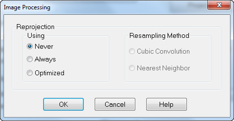
2) Disable MapInfo's on the fly reprojection support.
Navigate to Map>Options>Image Processing and set this to Never.
Note that the map option will be saved in workspaces, and needs to be changed in all existing windows.
You should also adjust the default settings under Options>Preferences>Image Processing, to Never.

The reason you see the shifting is because this image processing is an approximation of reprojecting on the fly (wheres as Vector files are always automatically correctly reprojected on the fly in MapInfo Professional to the current Map Windows projection).
Note that once this is set to Never (off), the Map window's projection will change the the first Raster/Surface layer's projection.
All other images/raster need to be in the same projection to place in the same window. See the related articles on how to reproject these.
If the shifting persists, the raster/surface image will have errors in its registration, as seen under Table>Raster>Modify Image Registration. To remove these errors, use the Discover's Rectify image tool with the existing control points. See the related article on registering/rectifying images.


