Two methods are available within the MapInfo Pro and MapInfo Discover product suite to register raster images in real-world coordinates.
The process of registering an image involves associating map coordinates, usually X and Y, with corresponding pixels on an unregistered image.
MapInfo Pro Image Registration
Table>Raster>Modify Image Registration…
The MapInfo Pro registration process will register points on an image with the assigned X and Y values, and locate as defined by the specified projection. This process is satisfactory if no distortions or rotations exist in the unregistered image file.
However, if you are using an image which is skewed, stretched or distorted e.g. from scanning, the image registration process within MapInfo Pro will not adjust the image to accommodate localised distortions.
For example, if there is significant error (pixels) in the registration points, this indicates the image does not match and requires warping to correctly match the desired map registration points.
What difference does this make and what are the consequences of a distorted image to
my map?
The difference this makes to a mapper window can be dramatic, depending on the amount of distortion or rotation, following the registration of a distorted image. You may observe considerable distortions in vector layers located in the mapper window. This is due to the mapper window manipulating the coordinate system grid around the distorted registered image. As a consequence the vector layers will be located in the correct coordinate space, but will appear either distorted or incorrectly orientated, and the raster image may also shift as you zoom/pan.
An example of MapInfo Pro registration can be observed in Images 1 & 2: Image 1 is an unregistered image with a rotation; Image 2 displays a MapInfo Pro registered image. What can be observed is the image rotation after registration; the overlain blue polygon has rotated with the registered image. Although the vector layers are located in the correct space relative to the image, the grid north for the projection is rotated.
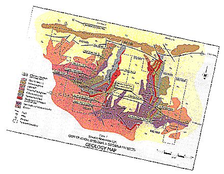
Image 1: Original unregistered image with rotation
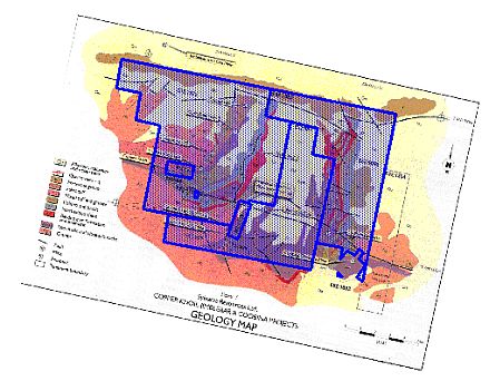
Image 2: MapInfo registered image
MapInfo Discover Image Rectification
Discover>Images>Rectify Image
The MapInfo Discover Rectify Image tool can register and modify images that have been stretched, skewed or rotated. This process known as “Rubber-Sheeting” and allows the image to be stretched or warped to conform to the user-entered control points. This can often effectively reduce the registration errors to 0.
An example of MapInfo Discover rectification can be observed in Images 3 & 4 below. Image 3 is an unregistered image with a rotation, while Image 4 displays a MapInfo Discover registered image. What can be observed is the rotation adjustment after registration; the overlain blue polygon has not been rotated as observed with the MapInfo Pro process. The vector layers are located in the correct space relative to the image and grid north is orientated as expected.
Image 3: Original unregistered image with rotation
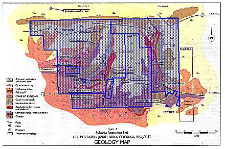
Image 4: MapInfo Discover rectified image and vector layer


